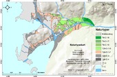
| dc.description.abstract | Glaciers are sensitive indicators of climate. In southwestern Norway, the Buerbreen glacier reached its maximum extent in the little ice age in the late 1870s, followed by a subsequent retreat due to temperatures rising. Large areas have been exposed, enabling the process of a primary succession, that also is susceptible to other disturbances. At the same time, long term and varied land use has influenced the vegetation in Øvre Buerdalen, leading to a multidimensional vegetation dynamic in the area. The aim of this study is to detect vegetation development and analyse the influence of climatic- and land use change on flora in Øvre Buerdalen in recent times. The forest is emphasized, and its expansion since 1981 in the glacier foreland and the treeline fluctuations in associated hillsides are investigated. In the glacier foreland, the condition of the forest is estimated with variables standardized by the methodology Natur i Norge (NiN) vol. 2. This methodology is also used to undertake a vegetation mapping within the glacier foreland. Together, the methodology gives an overview of the state and the variation of the vegetation today. Besides NiN, aerial and historical photos, interviews, field surveys (with GPS), soil analysis and climate- and glacier measurements is the basis for understanding the complex dynamic vegetation change in Øvre Buerdalen. GIS has been a useful tool for storing, conduct and display spatial data. The results shows that the glacier foreland consist of an amount of the thermophilic deciduous forest species Ulmus glabra, in its lower parts. The soil development is at a faster rate than expected for glacier forelands in Norway, and the forest is in a well- established succession stage, with ecosystem functions typical for natural forest at older substrate. At higher altitudes, the forest has expanded, primary by Betula pubescens ssp. Czerepanovii, which also creates the alpine treeline in the mountain. Here, the forest lies at or near its climatic upper limit on the northern side of the valley, and under its climatic limit in the southern side, due to land use. Nevertheless, the main factor for vegetation development in the study area since 1981, is climatic change. | en_US |

